
Drawing > Others > World CS
You can access the functions for 3-D coordinate systems via Drawing > Others > World CS.
![]()
![]()
Drawing > Others > World CS > Activate World CS
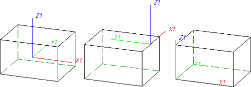
You use this function to switch to the world coordinate system (standard coordinate system). This coordinate system is automatically active when a new drawing is created. Its reference point lies in the point (0,0,0), while the xy-plane is the top view plane. By choosing another view and by moving the screen display, you can change the position and the orientation of the world coordinate system even before you start your drawing.
![]() Please note:
Please note:
![]()
![]()
Drawing > Others > World CS > Activate Part CS 
You use this function to activate the part coordinate system of the active 3-D part. A part coordinate system is automatically assigned to every 3-D part of your drawing when it is created and saved together with the drawing. Part coordinate systems are required, for example, for clones and can be rotated and moved freely.
![]() Changes to the part coordinate system are lost if you activate another
coordinate system and do not save the drawing with the modified part coordinate
system beforehand.
Changes to the part coordinate system are lost if you activate another
coordinate system and do not save the drawing with the modified part coordinate
system beforehand.
![]()
![]()
Drawing > Others > World CS > Processing plane 
This function enables you to define a local coordinate system temporarily by specifying a processing plane.
To specify the processing plane, you can identify points, edges, surfaces and even processing planes in the drawing. You can access further functions for specifying the processing plane by pressing the mouse button instead of making an identification.
![]() The local coordinate system remains active until you define a new one
or switch intermittently to the world coordinate system or a part coordinate
system.
The local coordinate system remains active until you define a new one
or switch intermittently to the world coordinate system or a part coordinate
system.
![]()
![]()
Drawing > Others > World CS > Define Fitting CS 
This function enables you to define a fitting coordinate system in the same way as when creating 3-D processing planes. It has the following properties:
Referenced components are assigned the standard fitting coordinate system when they are saved if they do not already have their own fitting coordinate system. The standard coordinate system is defined in this case by means of the points (0,0,0), (1,0,0) and (0,1,0).
![]()
Related Topics
Version 1702 - HiCAD Basics | Date: 9/2012 | © Copyright 2012, ISD Software und Systeme GmbH


